Wednesday, May 6, 2015

Bibliography

Text Sources

Cartier, Jacques, Henry Percival Biggar, and Ramsay Cook. The Voyages of Jacques Cartier. Toronto: University of Toronto Press, 1993.

Columbus, Christopher, Bartolomé de las Casas, and Van Wyck Brooks. Journal of First Voyage to America. New York: A. & C. Boni, 1924.

Hampden, John. New Worlds Ahead: Firsthand Accounts of English Voyages. New York: Farrar, Straus & Giroux, 1968.

Love, Ronald S. Maritime Exploration in the Age of Discovery, 1415-1800. Westport, Conn: Greenwood Press, 2006.

Mallery, Richard D. Masterworks of Travel & Exploration: Digests of 13 Great Classics. Garden City, N.Y.: Doubleday, 1948.

Morison, Samuel Eliot. The Great Explorers: The European Discovery of America. New York: Oxford University Press, 1978.

Payne, Stanley G. A History of Spain and Portugal. Madison, Wisc: University of Wisconsin Press, 1973.

Solsten, Eric. Portugal: A Country Study. Washington, D.C.: U.S. G.P.O., 1994.

Images & Videos

Figure 1.1: “Original Map of Juan de la Cosa” found at http://en.wikipedia.org/wiki/Map_of_Juan_de_la_Cosa on April 21, 2015.

Figure 1.2: “Columbus’s First Voyage” found at https://www.youtube.com/watch?v=JplrfydOmQo on April 21, 2015.

Figure 2.1: “Portrait of Prince Henry the Navigator” found at http://upload.wikimedia.org/wikipedia/commons/0/02/Henry_the_Navigator1.jpg on April 24, 2015.

Figure 2.2: “Map of Portuguese Explorers” found at http://mrclark.aretesys.com/portovoyages.jpg on April 24, 2015.

Figure 3.1: “Etching of Columbus’s Ships” found at http://upload.wikimedia.org/wikipedia/commons/3/3c/Gustav_Adolf_Closs_-_Die_Schiffe_des_Columbus_-_1892.jpg on April 27, 2015.

Figure 3.2: “Ferdinand Magellan” found at https://www.youtube.com/watch?v=_XpxHsYaohg on April 27, 2015.

Figure 4.1: “Northwest Passage” found at https://www.youtube.com/watch?v=IR5CSRkSz64 on April 30, 2015.


Figure 4.3: “Henry Hudson” found at http://cdn.history.com/sites/2/2013/11/henry-hudson-AB.jpeg on May 2, 2015.

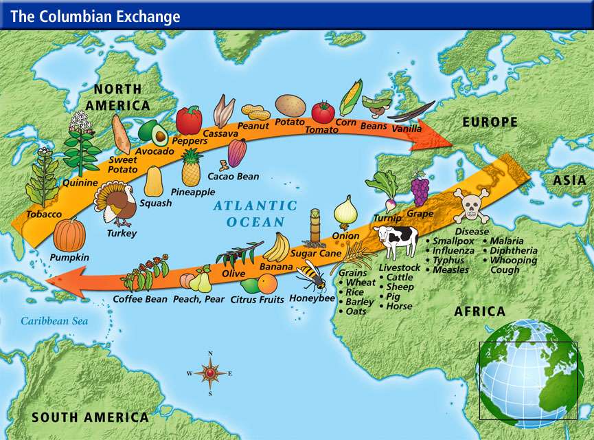
Figure 5.1: “Columbian Exchange” found at http://globerove.com/wp-content/uploads/2010/03/Columbian-Exchange.jpg on May 4, 2015.

Figure 5.2: “Mercantilism” found at https://s-media-cache-ak0.pinimg.com/736x/b6/a2/ca/b6a2ca54a43b0c68566a3991863ee76a.jpg on May 4, 2014.

No Spain, No Gain

With the Portuguese looking for sea-routes to India and Asia, their Spanish neighbors could not stay out of the search very long. The Spanish king and Queen, Ferdinand II and Isabel, had recently finished conquering the lands of the Moors in Spain, reclaiming the country as a Catholic domain. From here they had no where else to expand and, much like the Portuguese, turned their minds towards overseas expansion. They had seen the successes of the Portuguese in their search for the Indies and when a clever Italian, named Christopher Columbus, approached Isabel about the possibility of a trade route heading west, she felt compelled to support his endeavors. 


Figure 3.1: This is an etching of the Nina, the Pinta,
and the Santa Maria
After receiving the support of the Spanish royal court, Columbus set sail on April 3, 1492 with the famous trio of vessels: the Nina, the Pinta, and the Santa Maria—the last one being the flagship and captained by Columbus himself. Heading west past the Canary Islands, the famed voyage then headed southwest, propelled by brisk trade winds from the east or, the “easterlies”, believing they were headed directly for the eastern islands of Asia. Instead, the 88 man crew was on a five week journey from the Canaries towards the Bahamas. Early in the morning of October 12, 1492, Rodrigo de Triana, the lookout on the Pinta, spotted land. Later Columbus would claim to have seen a light shining from the island, later called San Salvador. The Italian explorer described the locals as

“well made with fine shapes and faces; their hair short, and coarse like that of a horse’s tail…Some paint themselves with black, which makes them appear like those of the Canaries, neither black not white.”

He continued his journey throughout the Caribbean, encountering numerous other islands, including: Inagua, Cuba, Hispaniola, Haiti, and the Dominican Republic. After his main voyage, Columbus had three other voyages to the “New World” in September 1493, May 1498, and May 1502.  From these he brought back indigenous people, gold, tobacco, potatoes, and many other plants and animals never before seen on the European continent.  Though he had found these new and exciting lands, Columbus still believed that he had reached the Indies and died with that belief. Much like the voyage of Vasco da Gama, Columbus’s discovery had forever changed intercontinental interaction.

Another man to sail under the Spanish crown without being a Spanish citizen was Ferdinand Magellan. Being a skilled naval officer from Portugal, Magellan was selected by Charles I of Spain, also Charles V of the Holy Roman Empire, to lead a Spanish expedition westward to the Asian “Spice Islands”. The former naval officer, once fallen from grace was to take a crew of 270 men, comprised of all nationalities in search of a gateway from the Atlantic to the South Pacific by crossing through South America. Studying countless charts and maps, he believed the crossing would make it possible to reach the Indies without upsetting the delicate balance of Spanish and Portuguese colonial power. The fleet of five ships left Sevilla, Spain on August 10, 1519 and headed towards the Canary Islands. Due to the need to resupply, avoiding both Portuguese ships and territories, and even an attempted mutiny off the coast of Argentina, the fleet took over one year but it finally reached the Cape Virgenes on October 21, 1520. After a weeks rest, the fleet slowly sailed through the presently-named Strait of Magellan until November 28, when they finally reached the Pacific Ocean, named for its apparent stillness. The happiness was short-lived, however, as the Spanish came to the Philippines. There, after converting two of the local rulers to Christianity, a small battle with a third resulted in the death of Magellan. After his death, the crew fled to the Maluku “Spice Islands” and finally traded for the goods they had come for. After this, the remaining men returned to Spain by circumventing the Cape of Good Hope. Only the Victoria, with 18 men in total, made it back to Spain alive on September 6, 1522. After an expedition of almost three years, the crew had become the first to ever circumnavigate the globe and prove that the Earth was, indeed, a globe.

  
Figure 3.2: A video explaining Magellan's voyage 

As Magellan and his crew set sail, other Spaniards were also hard at work. In 1519, Hernán Cortés set out to conquer the Aztec civilization of Mexico. With an army of 550 troops and 250 indigenous people, he fought a series of battles lasting more than a year and brought Central and parts of South America under Spanish control. His success was partly the result of obtaining allies from tribes that the Aztecs had previously conquered, while another was the superiority of European technology in small arms and artillery. By 1522, Cortés controlled a territory that was larger than that of Spain itself. But the human cost was immense; in a period of thirty years, the Aztec population was reduced from 25 million to 2 million people. This pattern of complete control was repeated wherever the conquistadors landed. For instance, in 1531, Francesco Pizarro easily conquered the Incan Empire of Peru. Gold and silver flooded back to Spain, especially after the huge silver deposits in the Andes Mountains were discovered. With all of these examples, Spain’s wealth and power continued to grow, expanding their interests as far as the eye could see. 

Monday, May 4, 2015

Portugal Travels Around the Tip of Africa

With the aforementioned advances in their sailing technology, Portugal was one of the first European monarchies to begin their quest for Asian spices. Being a small nation on the western coast of the Iberian peninsula, Portugal was did not have much opportunity to expand within their own country. The mountainous regions of the eastern border made also presented difficulties, along with the powerful, neighboring country of Spain, fresh off their defeat of the Muslims in Granada. This left Portugal with one option: maritime expansion.

Figure 2.1: A portrait of Prince Henry the Navigator
One of the main reasons that Portuguese maritime exploits became such a viable option was Prince Henry the Navigator. A loyal master of the Order of Christ, Prince Henry—son of Portugal’s King John I—felt it necessary to use his wealth and influence to aid in the expansion of Portuguese influence and, more importantly, Christianity. Establishing numerous naval schools, the Portuguese prince wanted to know more about the exploits available in Africa. From this curiosity, he financed numerous voyages along the western coast of Africa, establishing a variety of trade posts and Portuguese colonial foundations along the way. Eventually he visions extended beyond Africa’s west coast and around the tip of Africa. His visions, however, exceeded his lifespan as the great patron died in the year 1460.

There are two main explorers sailing under the Portuguese flag that are of major note in the conversation about the Age of Exploration. One of the most profitable explorers that studied at Prince Henry’s school was a captain named Bartolomeu Dias. His three ships set sail from Lisbon in 1487, taking a route along the west African coast, the very same utilized by his predecessors. As he followed coastline southward, the explorer took care to remain on course with the given route. The coastline, however, disappeared from view as the vessels were caught in a series of storms that lasted almost two weeks. They were blown to the south but the men were unsure how far off-course they had been directed. In order to correct their loss of direction, Dias headed east, hoping to eventually find the western coast of Africa. After a considerable amount of time, the ships failed to reach land and changed their course of direction northward. It was here, in February 1988 that they landed in Mossel Bay, present-day South Africa. The crew was tired and did not the adventurous excitement of Dias, leading to the decision to return to Portugal. It was on this return that the vessels actually encountered the Cape of Good Hope. Upon his return, Dias had so much to share with the nobility and his fellow explorers. One of these was to be his predecessor and the first European explorer to reach India by sea: Vasco de Gama.

Figure 2.2: A map comparing the different routes taken by the Portuguese explorers 

A young explorer ready to prove his worth, Vasco de Gama was just who the Portuguese needed to take command of the dangerous voyage around the southern tip of Africa. Using the same route along the west coast of Africa, de Gama left Lisbon with four ships late in the summer of 1497. In December of the same year, the captain and his men reached the Rio do Infante, where Dias had turned back, and began sailing into the uncharted waters off the eastern coast of Africa. During their voyage along the eastern shore, the Portuguese travelled through various cities including, Mozambique, Mobasa, and Malandi, where de Gama procured a navigator with knowledge of the monsoon winds to direct them to India. After almost of a year of sailing, the group landed near Calicut, India. While here, de Gama’s lack of gold or silver failed to impress the local ruler, but they still traded enough to finance the trip 60 times over. The outward trip, however, proved more difficult by taking months to sail against the wind. The journey took a long period of time and the men did not make it back to Portugal until the late summer of 1499, almost two years long. With this great achievement, Vasco de Gama not only proved that a sea route to India was possible, but he changed the practice of intercontinental trade forever.

Coming into the 16th century Portugal exploited their naval trade routes, becoming one of the most trade-rich countries in all of Europe. Using their newly discovered sea routes, Portuguese captains returned from their long voyages around the tip of Africa with highly sought-after spices, silks, and other goods that the world had not seen. The Portuguese even profited from one explorer's blunder. On a voyage in 1500, a nobleman named Pedro Álvares Cabral set sail with two fleets. Though both headed towards the Indian ocean, one of the fleets set their course too far west and landed upon the eastern coast of Brazil. This would become Portugal's main colony in the Americas and the Spanish-controlled western hemisphere. From these immense navigational feats one can see how Portugal became the first European nation to place such large stock in maritime trading and enterprise.


Tuesday, April 21, 2015

The Age of Exploration: Introduction


Figure 1.1: Juan de la Cosa's map is the earliest
representation of the newly discovered Americas.
When one studies the Age of Exploration, many students are quick to analyze the actions of Christopher Columbus. As an explorer financed by the Spanish monarchs, Isabel and Ferdinand II, he searched for a way to India by heading west across the Atlantic Ocean. Another popular topic in the Age of Exploration is the Portuguese explorer, Vasco de Gama, who proved that Asia, specifically India, could be reached by circumventing the Cape of Good Hope, located at the southern-most tip of Africa. And that is not without reason. These two men helped change the world, uncovering new trade routes to the far east and the continent of North America.

Why did people set off to explore the world in the fifteenth century? In short, there are two main reasons: spices and religion. Numerous countries had heard of or even experienced these newly acquired goods and they too wanted Asian spices. Italy and Egypt, however. controlled the trade routes to Asia, charging very high prices for spices. In fact, pepper cost more than gold. Many countries wanted to find a route to Asia so they too could get spices, any no longer deal with expensive Italian or Egyptian traders.

Other advances, mainly by the Portuguese, came in shipbuilding. These trade-hungry Europeans began building ships called "caravels". Caravels were a specialized type of ship, using triangular sails that, unlike traditional square sails, allowed ships to sail against the wind. They also replaced oars on the ship's sides with rudders at the back of the ship drastically improving the steering of these newly developed, Portuguese trading vessels. The new ships helped Portuguese sailors take and early lead in the European race to explore the globe. 

Religion gave explorers another reason to set sail. European Christians wanted to convert more people to their religion to counteract the spread of Islam in Europe, Africa, and Asia. Simple curiosity was also an important motivation for exploration. Many people read stories of Marco Polo’s travels and other explorers’ adventures throughout the continent of Asia. After learning about these exotically new lands and the wild creatures they possessed, the wealthy became evermore curious about what the rest of the world had to offer them.

Figure 1.2: This video is a dramatic representation of Columbus's 
first voyage to the New World.  

Whatever their reasons for exploring, Europeans would not have gotten very far without advances in technology. Sailors started using technology developed by the Muslims in the early 15th century such as the astrolabe and the compass to find the sea routes they could follow to reach faraway places and return safely home. The developments made in cartography and the availability of more accurate maps allowed sailors to sail from one port to another without having to stay right along the coast. Before these advances, most sailors avoided the open sea out of fear they might not find their way back to land.